If you’re here, you already know about the Greenbelt, so I won’t spend a lot of time selling it to you. I’m here to help you get the most out of it. A few things to remember for all access points:
** Like the roads in Austin, almost all the access points have multiple names. I’ve labeled each section with the most currently common name and listed any other names I’m aware of to help with confusion if you hear any of the other names. Also, technically, there are multiple Greenbelts throughout the city. This is focusing on “The Greenbelt”
** Austin is a dog city, but despite popular opinion, they are required to be on a leash at all parts of the trail.
** If you want to swim be sure and check the water level at each of the points on this website.
** There aren’t any restrooms, water fountains or trashcans on the trail itself, so bring water and dispose of trash (especially dog poop) at the access points.
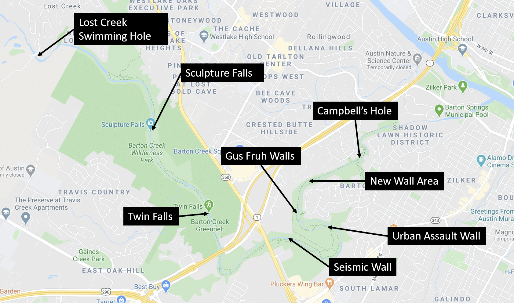
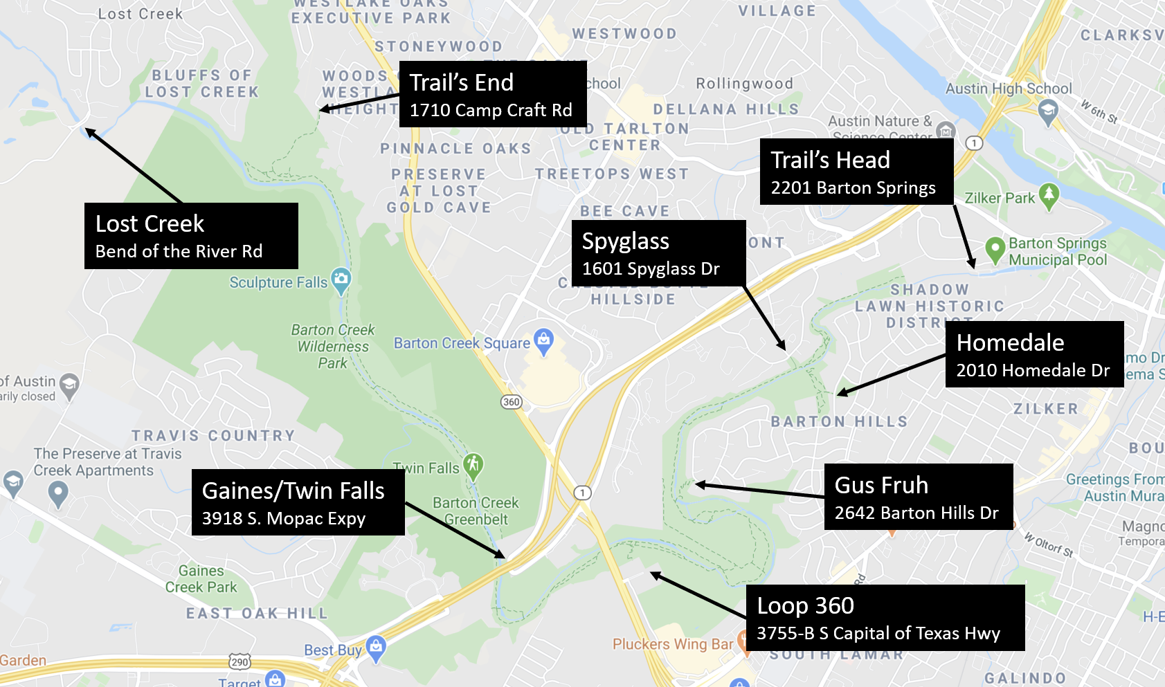
We link to a map of each entrance point in the text. For the more visual types, we’ve got maps of the access points, climbing walls, and swimming holes below.
And a big thanks to Bob Sihler for helping us get everything right, especially when it came to the climbing info.
With that out of the way, let’s get started.
Trail’s Head
2201 Barton Springs Road (map)
AKA Zilker Part point or Violet Crown Trailhead (more on that below) Generally thought of as the start of the Greenbelt, this access point is an easy, wide, and float hike for most. That also means they’ll be an above average amount of joggers and bikers. That plus it’s proximity to downtown means it can be a bad start if you want to avoid crowds. There’s plenty parking in and around Zilker Park, but it still gets busy on weekends and you do have to pay.
This is also considered the trailhead for the Violet Crown Trail, a still incomplete trail that will stretch in Hayes County. We’l talk about that more at the 360 access point which is closer to where Violet Crown actually separates from the Greenbelt.
Spyglass Access
1601 Spyglass Dr. (map)
AKA Campbell’s Hole West but even more commonly known as the “Taco Deli point” since there is a one available right near the entrance. This point has pretty convenient street parking and has swimming and climbing options.
If you turn left (north), you’ll come to the popular swimming spot, Campbell’s Hole. Reminder, check the water level or ask someone walking the other way before you make the whole trek.
If you turn right (south), you’ll hit the first big climbing area, New Wall. It’s made up of several different walls including the Random Wall, Great Wall, and the Terrace.
One last thing to consider, being a popular spot this area is more frequently patrolled by the police, so plan accordingly.
Homedale Access
2010 Homedale Dr. (map)
AKA Barton Hills Access or Campbell’s Hole East. So it won’t be a surprise to you to find out that if you’re want to see Campbell’s Hole from the east side you can use this access point at Barton Hills Elementary School. The street parking is located in a residential neighborhood, so try not to be a jerk. Again, head north to arrive at Campbell’s Hole.
There are additional hiking trails on the east side of the creek. So even if there’s no water, there’s still plenty to explore in this area.
Gus Fruh Access
2642 Barton Hills Dr. (map)
The Gus Fruh access point (sometimes known as the Rae Dell access point) has a very deep swimming hole. This means you can go off rope swings or one of the big cliff jumping points (as high as 50 ft)
You can get to many of the Gus Fruh walls, including Myth Wall, Rubber Wall, and Guide’s Wall by taking the switchbacks down to the beach and the walls will be very close on your right. If the creek is dry you cross the spur which will take you directly to the walls.
If you head south you can hit the Urban Assault climbing walls.
This trail has more gravel than most so you may want to think about footwear. Parking for this point is in a residential neighborhood, so again, don’t be a jerk.
Loop 360
3755-B S Capital of Texas Hwy (Map)
Loop 360 is the access point you’ll get if you Google for Greenbelt access. That’s why it is sometimes called the “official access point to The Greenbelt”. Sometimes it is called, a little derisively, the Tourist Access Point as well. It’s really weird since it’s actually an office building parking lot. There’s a designated parking lot with overflow parking in the office park on weekend s. You’ll be able to see the distinct Austin Parks and Recreation sign as you pull up.
Once you get to the trail, you’ll probably notice a lot more mountain bike since the terrain there is really what they are looking for.
It’s easy to get to the Seismic Wall (also known as Maggie’s Wall) by just following the main trail to the creek and crossing.
The only downside to this section of the greenbelt is the noise from the highway. Depending on what you’re doing and how much this will bother you, you may have to consider another part of the belt.
If you follow the Greenbelt trail past the 360 entrance almost to where it crosses over MoPac you will come to a fork. If you keep heading south and don’t go across MoPac you’ll be on Violet Crown
Gaines/Twin Falls Access
3918 S. Mopac Expy (map)
This entrance has no parking lot so this access point can be difficult to, well, access. From Capital of Texas Highway, turn as if you’re heading south on MoPac. Remain on the frontage road, don’t take the ramp to MoPac. Just past the ramp, look for parked cars on the right side of the road, and you’ll find the entrance near the U-turn.
This access point remains popular despite this difficulty since it is great for hikers, trail runners and mountain bikers because of the varied terrain. There is also great swimming at Twin Falls.
Trail’s End
1710 Camp Craft Road (map)
AKA Scottish Trails access point. The western entry point is technically the ‘end’ (but not really) of the trail, and it can be a grueling goodbye.
This part of the trail includes the Hill of Life that is made up of loose rocks, concrete ledges, and a 300-foot change in elevation in less than half a mile. Sculpture Falls is a nice swimming hole reward if you can make it that far, and the fact that this part of the trail is challenging means it is generally more secluded.
To get there, turn on to Scottish Trail Rd from 360 and take it till it dead ends into Camp Craft Rd. It will probably be easier to park on Scottish Trail than Camp Craft. Again, you will be in a residential neighborhood with no bathrooms. Please don’t be a jerk.
Lost Creek
Bend of the River Drive (map)
You may have noticed how often I’ve mentioned not being a jerk when you are in residential areas. The Lost Creek access point is why. See, it’s not really lost at all anymore. In fact, it’s quite the party spot. So much so that people have really taken advantage of it and not been good neighbors when they go there. As a result, the neighborhood has started charging non-residents for going there to pay for clean up.
With that in mind, let’s talk about how to get there. After you’ve parked and gotten on the trail, you’ll quickly come upon the first swimming hole. It has a huge flat rock in the middle of it where people will set up shop. It’s a relaxing spot and you can have a great time there. It is not the Lost Creek though.
Cross the creek and keep going down the trail. It is a flat, easy hike. However, it is a 20-25 minute hike. That’s where the ‘Lost’ part of Lost Creek comes from. Other than that it is easy to find and you will hear music and beer being crushed before you get there.
That’s all 8 access points. Is there anything else everyone should know about these spots? Have you heard any different names for any of them? Feel free to leave a comment if so.
MAP OF GREENBELT ACCESS POINTS
MAP OF GREENBELT CLIMBING WALLS AND SWIMMING HOLES